BC Hydro’s North Coast Transmission Line will extend approximately 440 kilometres between Prince George and Terrace, generally following existing transmission infrastructure. Published maps identify the proposed route corridors, but they do not establish precisely which private properties will be affected.
Owners along the route may face new or expanded rights of way, access roads, vegetation clearing and construction activities. A property outside the mapped transmission corridor may also be affected by related works.
BC Hydro’s project map covering Phases 1, 2 and 3 provides a starting point. Confirming the position of an individual parcel requires a review of land title records, existing rights of way and, where available, property-specific plans and acquisition documents.
This article examines the Phase 1 and Phase 2 routes as published on November 10, 2026, the construction areas that may affect nearby properties and the records owners and purchasers should examine.
Where Does the North Coast Transmission Line Run?
The project is being developed in two phases, extending from Williston Substation near Prince George to Skeena Substation in Terrace.
Phase 1: Prince George to Fraser Lake
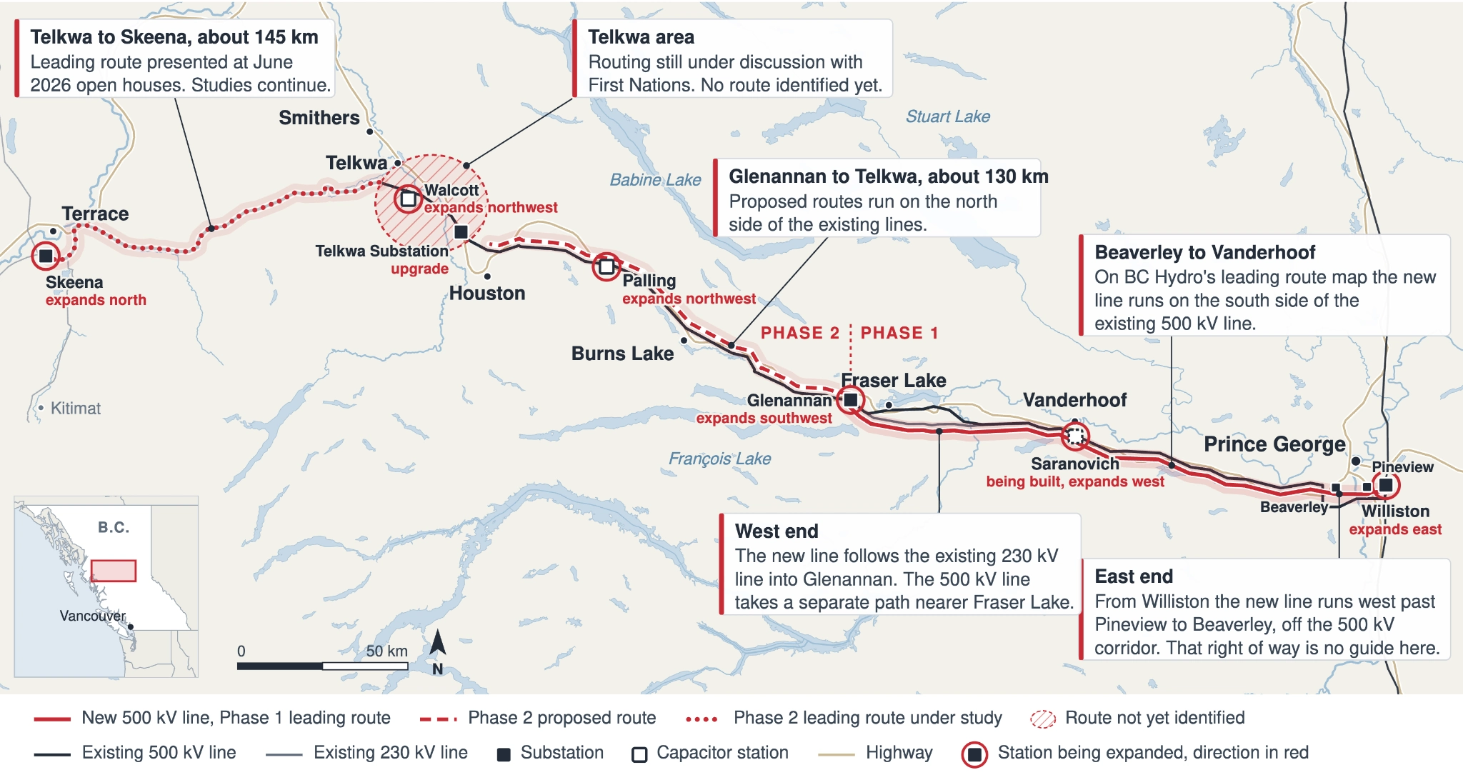
Phase 1 involves approximately 165 kilometres of new 500 kV transmission line between Williston Substation and Glenannan Substation near Fraser Lake. The route passes through the Prince George, Vanderhoof and Nechako Valley areas.
BC Hydro selected a leading route following consultations with First Nations partners and input from stakeholders. The published alignment generally follows existing transmission infrastructure, although deviations occur near both ends.
BC Hydro’s schedule identified summer 2026 for the start of construction, and work is now underway. The target in-service date is fall 2030.
Phase 2: Fraser Lake to Terrace
Phase 2 involves approximately 275 kilometres of new 500 kV transmission line from Glenannan Substation to Skeena Substation, passing through the broader Burns Lake, Houston, Telkwa and Smithers areas.
BC Hydro divides Phase 2 into two sections: approximately 130 kilometres between Glenannan and Telkwa substations, followed by approximately 145 kilometres between Telkwa and Skeena substations.
Route studies and property rights acquisition are scheduled to continue through 2027. Major construction is planned to begin in spring 2027, with a target in-service date of mid-2032.
Some Phase 2 routing options remain under consideration, particularly around Telkwa. Consequently, the published corridor should not be treated as a final surveyed alignment.
The distinction matters for owners evaluating property transactions, land development or proposals from BC Hydro. Additional information about potential acquisitions and compensation appears in ATAC LAW’s guide, North Coast Transmission Line: Your Rights to Compensation if BC Hydro Needs Your Land.
What Do the Phase 1 Route and Construction Maps Show?
BC Hydro publishes a leading route map and separate construction segment maps for Phase 1. The maps serve different purposes.
The Leading Route
BC Hydro’s selected Phase 1 route generally follows the existing 500 kV transmission line, with two identified exceptions.
At the eastern end, the new route travels west from Williston Substation to Beaverly Substation. At the western end, it follows the existing 230 kV line rather than the 500 kV corridor.
These deviations are important because the location of an existing transmission line does not necessarily identify the land required for the new one.
The Phase 1 project page contains the leading route map, project schedule and open house materials.
Construction Segments
BC Hydro has divided the transmission corridor into lettered construction segments and publishes updates identifying planned and active work.
As of November 2026, reported activities include access road construction, bridge replacement and transmission line relocation in Segment A1 between Prince George and Beaverly.
In Segments D, E and F, between Culculz Creek, Sinkut River, Stony Creek and the Nechako River, activities include timber clearing, aggregate development, right-of-way preparation and road construction.
The segment maps identify construction areas, but they do not establish legal parcel boundaries or prove that BC Hydro has acquired rights over every property within a segment.
Owners can review the construction segment maps and current bulletins to identify work planned near their property.
Which BC Energy Regulator Permits Apply to Phase 1?
The BC Energy Regulator has published three primary permit bundles relating to Phase 1 activities:
- DEF bundle: Issued July 27, 2026, with 30.858 hectares of approved disturbance.
- A1 bundle: Issued September 14, 2026, with a subsequent correction dated September 21, 2026.
- GH bundle: Issued October 22, 2026, with 113.689 hectares of approved disturbance.
The permits authorize specified activities within defined areas, including transmission line works, access roads, workspaces and changes in and about streams.
The approvals issued under the Energy Resource Activities Act contain conditions governing the authorized activities. Associated authorizations under the Land Act concern occupation and use of Crown land.
A regulatory permit does not, by itself, establish that BC Hydro has acquired a right of way or other property interest over an individual private parcel. Existing registered interests, negotiated agreements, expropriation procedures and BC Hydro’s statutory powers must be considered separately.
The permits and associated authorizations are available through the BC Energy Regulator’s North Coast Transmission Line project page.
Where Does Phase 2 Run, and Which Routes Remain Under Consideration?
BC Hydro’s Phase 2 project page contains separate maps for the Glenannan-to-Telkwa and Telkwa-to-Skeena sections.
Between Glenannan and Telkwa substations, the proposed routes generally parallel existing transmission lines on their northern side. This identifies an area requiring closer examination but does not establish that every property north of the existing line will be affected.
Between Telkwa and Skeena substations, BC Hydro presented a leading route for the western section at public open houses in June 2026. Further studies are continuing, and routing options around the Telkwa area, including the area referred to as Bulbous Toe, remain under discussion with First Nations.
BC Hydro has indicated that a leading route for the unresolved Telkwa section will be identified later. It is also examining alternatives where the new transmission line cannot follow existing infrastructure.
Until the alignment and property requirements are confirmed, an owner should not rely on the published maps alone when determining the effect on a particular parcel.
Which Substations and Construction Areas May Affect Nearby Properties?
The project includes modifications to existing electrical facilities, in addition to new transmission lines.
For Phase 1, BC Hydro proposes to expand Williston Substation eastward, Glenannan Substation southwestward and Saranovich Capacitor Station westward.
Phase 2 includes upgrades to Glenannan and Telkwa substations, an expansion of Skeena Substation northward, and northwestward expansions of Palling and Walcott capacitor stations.
The project also requires supporting infrastructure, including access roads, laydown yards, workforce accommodation and temporary construction areas.
BC Hydro’s published construction information identifies a workforce accommodation site and laydown yard in Vanderhoof, a laydown yard in Prince George, access road and bridge works, and geotechnical investigations at selected locations.
Such activities may require land outside the transmission corridor. However, the legal basis for occupation varies. BC Hydro may rely on an existing interest, a negotiated agreement, Crown land authorization or an applicable statutory power.
The project should also be distinguished from the separate Prince George to Terrace Capacitors Project, which involves additional facilities along the existing 500 kV transmission system.
Can Properties Outside the Transmission Corridor Be Affected?
Yes. A property does not need to be crossed by the transmission line to be affected by construction or certain statutory activities.
The principal situations involve new property interests, temporary access, vegetation clearing and works on neighbouring land.
- New or expanded rights of way: BC Hydro may require a registered interest permitting construction, operation and maintenance of transmission facilities. The scope of permitted activities and restrictions on the owner’s use depends on the rights acquired.
- Access roads and temporary work areas: Construction may require entry, road improvements, equipment storage or temporary occupation. The legal basis, duration and compensation arrangements depend on the circumstances and any applicable agreement or statutory authority.
- Tree removal: BC Hydro may have authority to remove trees outside a registered corridor where the statutory conditions are met. The existence and amount of any compensation claim require separate assessment.
- Adjacent construction: A property near a substation, yard or construction area may experience noise, traffic, vibration or other effects. Those consequences do not automatically create a legal right to compensation, although particular damage may support a claim.
The distinction between acquiring property rights and exercising statutory powers is important. Each may involve different procedures and compensation requirements.
Can BC Hydro Enter Land or Remove Trees Without Permission?
Section 20(1) of B.C.’s Hydro and Power Authority Act gives BC Hydro specified powers to enter land without the owner’s consent for purposes related to its existing or projected electrical facilities.
These powers include conducting surveys and tests, removing trees that BC Hydro considers capable of endangering its infrastructure, and making or using roads, trails, bridges and other facilities required for access.
The powers are not limited to land already subject to a registered transmission right of way.
Section 20(2) provides for compensation claims concerning damage to crops, gardens, shrubs, trees and other growing things, as well as other damage caused by or incidental to the exercise of those powers. Where the parties cannot agree on compensation, the Supreme Court of British Columbia determines the amount.
This does not mean every tree removed creates an automatic, separate payment. The circumstances of the removal, the damage sustained and any existing property rights must be examined.
Owners should establish the legal authority BC Hydro proposes to exercise and document the condition of the affected property before entry or clearing takes place.
How Can an Owner Confirm a BC Hydro Right of Way on a Property?
A current land title search is a principal source for identifying registered property interests. It may disclose a statutory right of way, easement, covenant or expropriation-related filing.
Under section 218 of the Land Title Act, a statutory right of way may be created in favour of qualifying entities, including the Crown, Crown corporations and public utilities.
Registration creates a charge on the affected land. The registered instrument establishes the rights granted, and its terms generally bind subsequent owners in accordance with the legislation.
The Registered Plan and Charge Document
The deposited statutory right of way plan ordinarily identifies the boundaries and dimensions of the affected area. Section 113 of the Land Title Act generally requires a plan before registration, although the registrar may dispense with that requirement on grounds of hardship or economic loss.
The charge document must also be examined. It may specify permitted construction and maintenance activities, access rights and restrictions on buildings, vegetation or other uses.
An existing right of way granted decades earlier may already authorize some additional infrastructure, depending on its terms. The presence of an existing transmission line does not automatically mean a new agreement or additional compensation is required, nor does it establish that BC Hydro has sufficient rights for every proposed activity.
ParcelMap BC and Survey Records
The Land Title and Survey Authority’s ParcelMap BC can assist owners in locating a parcel relative to neighbouring lands and the general project corridor.
However, ParcelMap BC is not a substitute for the underlying survey records or a property-specific legal assessment.
Equally, a title search showing no registered BC Hydro right of way does not conclusively establish that the proposed project will avoid the property. Rights may still be under negotiation, and certain statutory entry powers do not depend on registration.
Where the route is uncertain, owners may need to request property-specific plans from BC Hydro and obtain professional survey or legal advice.
What Should a Buyer Check Before Purchasing Property Near the Route?
A purchaser considering land near the project should investigate existing registered interests and any proposed acquisition or construction activities before completing the transaction.
The relevant records include:
- A current title search: Identify registered charges, rights of way, easements, covenants and expropriation-related filings.
- Registered instruments and plans: Obtain the documents defining BC Hydro’s rights and the land affected.
- BC Hydro correspondence: Request disclosure from the vendor of notices, proposals, access requests, compensation offers and agreements.
- Project maps and proposed works: Compare the property’s legal description with BC Hydro’s published alignment and any property-specific plans available.
- Unregistered agreements: Investigate arrangements signed by the vendor that may affect the property but are not yet reflected on title.
Under section 6 of the Expropriation Act, an expropriating authority commencing the ordinary statutory notice process must serve the required notices, post the prescribed sign or use the applicable alternative, and file the notice in the land title office.
For land outside a municipality, section 6(2) permits newspaper publication instead of posting a sign. The absence of a visible sign therefore does not establish that no expropriation process has commenced.
A properly filed expropriation notice is reflected in land title records, but a title search will not necessarily disclose negotiations or voluntary agreements that have not been registered.
The Land Title and Survey Authority provides instructions for searching titles and obtaining registered documents and plans.
Can BC Hydro Change the Route After Publishing a Map?
Yes. Published alignments may be refined as project studies, engineering design, regulatory approvals and engagement continue.
For example, BC Hydro sought public feedback concerning a proposed 12.4-hectare boundary adjustment to Swan Creek Protected Area to accommodate the North Coast Transmission Line. The proposal illustrates how environmental and route-planning issues can require changes to the project footprint.
An owner should distinguish between BC Hydro’s route-selection process and a statutory expropriation proceeding.
Does an Owner Have a Right to a Public Expropriation Inquiry?
Section 10(1) of the Expropriation Act defines linear development to include an electric transmission or distribution line.
Under section 10(2), the ordinary right to request an expropriation inquiry does not apply where the expropriation is for the construction, extension or alteration of a linear development.
Consequently, an owner affected by a qualifying transmission line expropriation cannot demand that statutory inquiry merely to challenge the proposed alignment.
This exclusion does not eliminate every possible legal challenge. Questions concerning statutory authority, procedural compliance, constitutional obligations and the exercise of public powers may require separate consideration.
A disagreement about the location of the line is also distinct from a dispute about compensation for property rights acquired.
What if the Property Is Affected but No Land Is Taken?
Damage caused by BC Hydro’s statutory entry powers may give rise to a claim under section 20 of the Hydro and Power Authority Act.
A different legal framework may apply where an expropriating authority’s works cause injurious affection without acquiring the owner’s land.
Section 41 of the Expropriation Act preserves certain claims for injurious affection where no land is taken. However, compensation is subject to established legal requirements and does not arise merely because a nearby project reduces a property’s perceived desirability.
Section 42 imposes a one-year limitation period for claims under section 41, calculated by reference to when the damage was sustained or became known to the claimant.
Owners should distinguish direct physical damage, the loss of property rights and other effects on land value before assessing a claim. For an overview of statutory compensation disputes, see ATAC LAW’s article on challenging a low expropriation offer.
Legal Advice on North Coast Transmission Line Property Rights
The North Coast Transmission Line may affect property through new rights of way, access arrangements, construction activities and vegetation removal. Determining the legal consequences requires a review of the specific parcel, BC Hydro’s existing rights and the activities proposed.
ATAC LAW represents property owners in transmission line right of way matters, statutory acquisition proceedings and expropriation compensation disputes. The firm’s expropriation law practice addresses land valuation, partial takings, access arrangements and the effects of infrastructure works on remaining property.
Owners and purchasers who have received a BC Hydro notice, access request, proposed agreement or compensation offer may contact ATAC LAW to arrange a review of the relevant documents before signing an agreement or responding to a statutory notice.